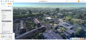
3D Cityplanner Adds Cesium Layer and Google 3D Mesh Integration
New features allow planners to add Cesium layers and Google 3D mesh data directly into their projects.
AMERSFOORT, UTRECHT, NETHERLANDS, September 5, 2025 /EINPresswire.com/ -- Strategis Groep, the company behind 3D Cityplanner, announces two major updates that expand the possibilities for digital urban planning: adding Cesium layers and integrating Google 3D mesh data through Cesium Ion.
With these features, urban designers, municipalities, and developers can seamlessly combine high-quality 3D data with their planning projects, creating a richer and more accurate digital twin of their environment.
The new Cesium Layer option allows users to import external 3D tilesets or geographic datasets directly into the 3D Cityplanner environment. This gives planners flexibility to integrate terrain models, infrastructure data, and other geospatial resources into their design workflows.
In addition, the Google 3D Mesh via Cesium Ion integration provides access to detailed 3D surface models of entire cities. This high-resolution mesh data allows professionals to visualize real-world surroundings with unprecedented detail, enhancing analysis, stakeholder communication, and scenario comparison.
Anne Dullemond, CEO of Strategis Groep, emphasizes the importance of the update:
“With the combination of Cesium and Google 3D Mesh, our users gain access to powerful tools that bring projects to life. This makes urban planning more transparent, collaborative, and future-proof.”
The updates are now available to all 3D Cityplanner users. More information, including a step-by-step guide on how to activate the Cesium layer and link Google 3D Mesh data, is available on the official help pages:
How to Add a Cesium Layer
Adding Google 3D Mesh Data through Cesium Ion
About 3D Cityplanner
3D Cityplanner is an interactive online tool for designing, analyzing, and visualizing urban development projects. It combines geodata, 3D visualization, and calculation tools into one platform, making it easier for municipalities, developers, and consultants to create sustainable and future-proof plans.
Anne Dullemond
Strategis Groep bv
+31 6 22443527
email us here
Visit us on social media:
LinkedIn
YouTube
X
Legal Disclaimer:
EIN Presswire provides this news content "as is" without warranty of any kind. We do not accept any responsibility or liability for the accuracy, content, images, videos, licenses, completeness, legality, or reliability of the information contained in this article. If you have any complaints or copyright issues related to this article, kindly contact the author above.

